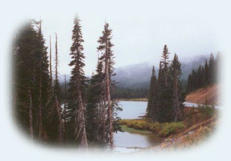
Devil's Lake in the Rain:

The Cascade Lakes Scenic Byway in the Cascade Mountains of Oregon.

devil's lake: high mountain lakes in the cascade mountains of oregon.

Forward ~ Wildlife Viewing in the High Desert
of Eastern Oregon.

Back ~ Paulina Waterfall in the Newberry Volcanic National Monument.

USFS: The Deschutes Ochoco National Forest.

The Cascade Lakes Hwy runs parallel to Hwy 97. You can connect with it via Hwy 58 or Hwy 97 on the southern
end. If you're on 97 turn west at Crescent. If you're on Hwy 58, turn east at the directional sign for Crescent. When you see
the sign for the Cascade Lakes Hwy, turn north. Vista points abound on the Cascade Lakes Hwy. Mountain Lakes, more
than can be seen from the road, but enough are easily seen to satisfy the most avid sightseer. Lava Lake, Devil Lake,
Sparks Lake, Elk Lake are right alongside the road. Access both Crane Prairie Reservoir and Wickiup Reservoir from
here. Somewhere in all of this are two small lakes, named Twin Lakes, motor-less lakes that must be good
for fishing, for my dad took us there every summer during my high school years.
I know they're good for swimming. :-)

Campgrounds abound along the Cascade Lakes Hwy. Not surprisingly, you'll find them on or near these lakes:
Two campgrounds are in close proximity to Lava Lake, one by Elk Lake, three in close proximity to Sparks Lake, two
on Crane Prairie, four on Wickiup Reservoir. It's possible to access the Scenic Waterway of the Deschutes River from
the Cascade Lakes Hwy. I recall an interesting interpretative viewpoint not long after we turned on the highway from the
south. It, explained why Ponder- osa Pine took root and thrived and just as quickly ended to be replaced by
Lodge pole Pine. It all boils down to volcanic activity, not surprisingly so. :-)

Cascade Lakes Hwy begins curving around to head east around Sparks and Devil Lake. You'll connect
with Century Drive, skirt the northern flank of Mt Bachelor, and finally arrive in Bend, Oregon.

Protect our National Forests and Wilderness Areas. Leave NO Trace!

volcanic lava flows in the cascade mountains or oregon - across from devil's lake, high mountains lakes in the cascades.

This site is not yet complete. I will have a travel directions
and map to include the the suggested scenery listed on the Central Oregon High Desert and Outback Tour and more than that which is listed, but this is not yet ready.

Brad and I invite you to explore the West Cascades National Scenic Byway: Travel Directions, Map: page 1 and page 2, and Scenery: mountains, hardened lava flows, wild and scenic rivers, waterfalls, hiking trails, hot springs, old growth forests, mountain lakes, forest service campgrounds and more.

The Crescent Lake, Oakridge "Inback" Tour:
Travel Directions and Map.

Travel Oregon and northern California while staying at Gathering Light ... a retreat
located in southern Oregon near Crater Lake National Park.


Links to the retreat only open a new window.

Travel to Gathering Light .... a retreat on the West Cascades National Scenic Byway: Directions, Map and Scenery: hiking trails, waterfalls, wild and scenic rivers, mountains, volcanoes, hot springs, Oregon scenic byways, wilderness areas and more.

Directions to and Day Trips of about 100 miles from the retreat.

Little known Scenic Places to explore nature untrammeled: hiking with and without trails, wetlands, wildlife refuges, mountains, river gorges, wilderness areas, wildlife viewing and more near Crater Lake and the retreat: Directions Map and Scenery.

The headwaters of kimball creek near gathering light ... a retreat located in southern oregon near crater lake national park: cabins, tree houses in the forest on the river.  

Website Directory

Page Listings

Home Page

Contact Brad at Gathering Light ... a retreat.

Valid XHTML 1.0 Transitional